
Earth (60)
Planet Earth, the only speck in the Universe confirmed by humans to have evolved higher forms of life. Watch NASA's phenomenal movie summarizing Life on Earth.
Children categories
Kamikatsu, Japan, famously declared its goal was to go waste-free by 2020. It didn’t quite get there.
This story was originally published in The Revelator
One of the many unfortunate outcomes of the coronavirus pandemic has been the quick and obvious increase in single-use plastic products. After COVID-19 arrived in the United States, many grocery stores prohibited customers from using reusable bags, coffee shops banned reusable mugs, and takeout food with plastic forks and knives became the new normal.
Despite recent scientific evidence that reusables don’t transmit the virus, the plastic industry has lobbied hard for a return to all things disposable plastic. Inevitably, a lot of that plastic will continue to flow into our environment.
While COVID-19 has certainly thrown a wrench into the hard-earned progress we’d been making in reducing waste, eliminating plastic pollution entirely was always going to be challenging — with or without a pandemic. The jarring rise of single-use plastics is an expedited version of a familiar trend. Plastic production has been steadily increasing for quite some time.
As a zero-waste advocate, I’ve seen how the tsunami of plastic continuously being produced and flooding our planet has made achieving zero-waste goals incredibly difficult. The sheer amount makes it hard to safely and efficiently dispose of plastic, no matter how hard we try.
But as I examine the problem, and search for solutions, I keep coming back to one noteworthy example.
- plastic pollution
- covid plastic increase
- reduce waste japan
- plastic recycling
- kamikatsu, japan
- the revelator
- reusable bag
- reusable packaging
- covid19
- zero waste
- waste free
- reusable mug
- reuse
- reduce
- recycling
- plastic industry
- nonrecyclable
- single use plastic
- mixed material
- food container
- bottle bill
- break free from plastic pollution act
A window on ursine motherhood in Cades Cove
As I was descending a wooded hillside in the heart of Cades Cove on a June afternoon, a motionless black bulk caught my eye off to my left.
I turned my attention there, regarded the scene for a few moments, and realized the sprawling blur was a large sleeping bear. A few moments more of inspection revealed three cubs snoozing in the branches overhead.
Report: Full regional mine reclamation costs approaching $10 billion as companies forfeit cleanup bonds
Written by Thomas Fraser
Report: Cascading bond forfeiture threatens surface mine cleanup
A new report from Appalachian Voices warns that mining companies will increasingly abandon reclamation bonds as the coal industry continues to decline in the Southern Appalachians, adding to already extensive public liability for cleanup costs.
Cleanup and reclamation with a price tag of nearly $10 billion must be still be done on 630,000 acres across seven states, according to the report, Repairing the Damage: The costs of delaying reclamation at modern-era mines.
Reclamation of lands and waters destroyed by coal surface mining could create some 40,000 jobs across the affected regions, virtually replacing, at least temporarily, all the mining jobs that have been lost during the past decade.
“The coal industry has declined precipitously in the last decade, raising the question of whether adequate regulations are in place to ensure that mined land is properly reclaimed,” according to a summary of the report, which was released July 7.
“As more coal companies declare bankruptcy, fewer companies remain to take over mines, so the number of companies forfeiting mining reclamation bonds and deserting their cleanup responsibilities will only increase. In many states, the funds generated by bonding programs may fall short of the actual reclamation costs that are passed to state agencies and taxpayers,” according to Appalachian Voices.
Despite Covid slowdowns and shutdowns, Smokies draws $1B in 2020 revenue to neighboring communities
Written by Thomas Fraser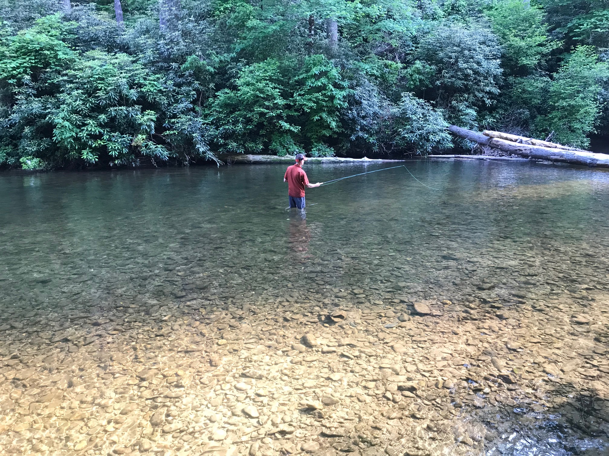 A Knoxville man tries his hand at fly fishing in Abrams Creek during a family camping trip on the southwestern side of Great Smoky Mountains National Park. Thomas Fraser/Hellbender Press
Green begets green in Smokies region; Big South Fork and Cumberland Gap also economic players
Recent federal analysis of spending by national park visitors is a testament to the economic benefits of environmental protection, scientific study and outdoor recreation.
The 12.1 million visitors to Great Smoky Mountains National Park in 2020 spent $1.024 billion in neighboring communities in both Tennessee and North Carolina, according to a study released this week by the National Park Service. Similar, localized releases were distributed into national park communities across the country.
Closer to home, that number represents the estimated visitor money spent in areas that include traditional “gateway” communities, such as Townsend and Gatlinburg, and Cherokee and Bryson City in North Carolina. Regionally, it’s at least a $5 million increase since 2012. Travel problems, housing and employee shortages, overdevelopment and environmental destruction are of course persistent in some of those areas.
- great smoky mountains economic impact
- great smoky mountains national park visitation
- conservation area economic impact
- big south fork
- big south fork national river and recreation area
- economic benefit of wild area
- obed
- cumberland gap
- federal park visitation and spending
- national park service units in tennessee
- economic impact of national parks in tennessee
Loghaven in South Knoxville melds natural and human habitats to serve regional artists
Written by Tracy Haun Owens Sanders Pace Architecture blended the collection of the decades-old cabins at Loghaven in South Knoxville with the existing natural environment. Photos by Anna Lawrence/Hellbender Press
Loghaven: An award-winning natural and built environment in South Knoxville intends to get minds moving
Five years after he first saw the property that would become Loghaven Artist Residency, architect Brandon Pace was in one of the renovated cabins, listening to a performance by now-late composer Harold Budd, in town to perform at the 2019 Big Ears music festival.
The experience brought home the full potential of a truly special place.
“That was wonderful,” Pace said of that moment. “You could see it being a place for a composer. You saw this could be something. You could see how our city comes alive in events like this.”
This spring, Knoxville-based Sanders Pace Architecture was awarded a 2021 AIA Architecture Award for the design and architectural rehabilitation work at the 90-acre Loghaven property, which is owned and managed by the Aslan Foundation.
“The role they play in supporting good design in our community cannot be overstated,” Pace said of the Aslan Foundation.
Team member Michael Davis was awarded the 2021 AIA Young Architects Award.
On June 1, Loghaven Artist Residency opened up the application process for its second class of in-person residents, artists who work in visual, performing, literary, and interdisciplinary artistic fields.
“Save Loghaven”
Loghaven is a uniquely quirky part of Knoxville history. It began as a collection of log cabins in a heavily wooded area along Candora Road in South Knoxville.
The cabins were built as rental properties by single mom and entrepreneur Myssie Thompson in 1935, in the middle of the Great Depression. Her cabins, as well as one built by neighbor John Hightower, are the heart of the property.
Generations of UTK students and professors, young professionals, and others rented the alluring cabins. But by the late 1990s, the area was sinking into disrepair, with kudzu, privet, and other invasive plants growing up around the cabins and previously cleared areas.
Great Smokies rangers levy fines against visitor feeding Cades Cove bear peanut butter
Written by Thomas Fraser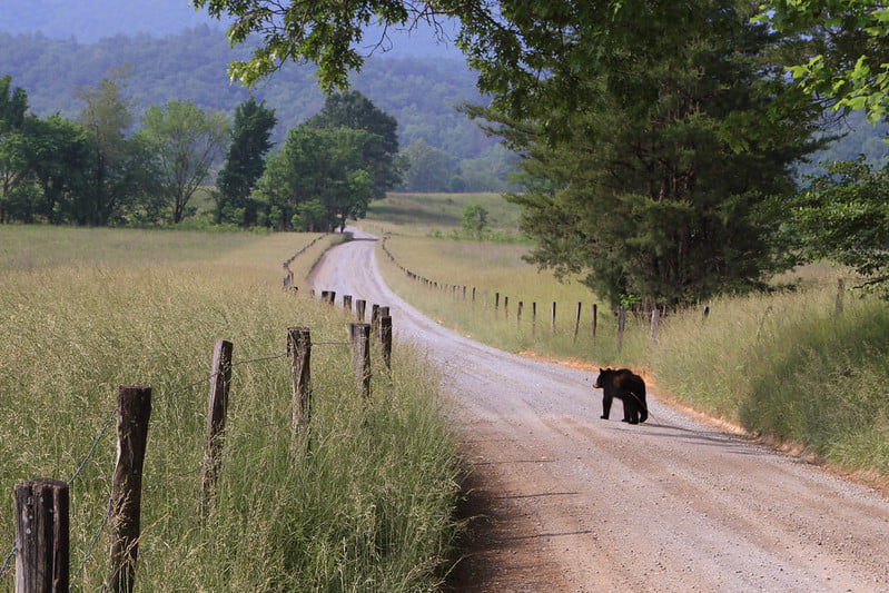 A black bear makes its way through Cades Cove in this National Park Service photograph. This is emblematic of Smoky Mountain bears on the move in the spring; the park service recently took action against a visitor who fed a bear peanut butter in the area. The bear in question had been feeding on walnuts for several weeks prior to the visitors’ introduction of human food, attractions to which can doom black bears because they are more prone to exhibit dangerous behavior toward people and become habituated, and even dependent, on their presence.
Smokies visitor feeding bear peanut butter in Cades Cove was reportedly caught on camera. That aided park rangers’ search for the perp.
A visitor to Cades Cove thought it would be wise to feed peanut butter to a black bear in Great Smoky Mountains National Park, and she got a ticket as a result. The person who received the citation, according to a news release from the park, was identified via video taken by another park visitor.
A National Park Service spokeswoman followed up with Hellbender Press the morning of June 8 in response to some questions. Rangers issued the citation to a 27-year-old woman, one of three adults in the vehicle. If the woman simply pays the fine and doesn’t contest it in court, she will pay a $100 fine, plus a $30 fee
Anyhoo, for Pete’s sake, don’t feed the bears. They’ve got enough problems without us getting involved.
“Managing wild bears in a park that receives more than 12 million visitors is an extreme challenge and we must have the public’s help,” said Great Smoky Mountains National Park Wildlife Biologist Bill Stiver. “It is critical that bears never be fed or approached — for their protection and for human safety.”
The full National Park Service release from Great Smoky Mountains National Park follows:
“Great Smoky Mountains National Park rangers issued a citation to visitors responsible for feeding a bear peanut butter in Cades Cove. Rangers learned about the incident after witnesses provided video documentation. Following an investigation, the visitors confessed and were issued a citation.
“Prior to the incident, the 100-pound male bear had been feeding on walnuts for several weeks along the Cades Cove Loop Road. The bear started to exhibit food-conditioned behavior leading wildlife biologists to suspect the bear had been fed. Biologists captured the bear, tranquilized it, and marked it with an ear tag before releasing it on site in the same general area. Through aversive conditioning techniques such as this, rangers discourage bears from frequenting parking areas, campgrounds, and picnic areas where they may be tempted to approach vehicles in search of food. This includes scaring bears from the roadside using loud sounds or discharging paint balls.
“Park officials remind visitors about precautions they should take while observing bears to keep themselves and bears safe. Until the summer berries ripen, natural foods are scarce. Visitors should observe bears from a distance of at least 50 yards and allow them to forage undisturbed. Bears should never be fed. While camping or picnicking in the park, visitors must properly store food and secure garbage. Coolers should always be properly stored in the trunk of a vehicle when not in use. All food waste should be properly disposed to discourage bears from approaching people.
“Hikers are reminded to take necessary precautions while in bear country including hiking in groups of three or more, carrying bear spray, complying with all backcountry closures, properly following food storage regulations, and remaining at a safe viewing distance from bears at all times. Feeding, touching, disturbing, or willfully approaching wildlife within 50 yards (150 feet), or any distance that disturbs or displaces wildlife, is illegal in the park.
“If approached by a bear, park officials recommend slowly backing away to put distance between yourself and the animal, creating space for it to pass. If the bear continues to approach, you should not run. Hikers should make themselves look large, stand their ground as a group, and throw rocks or sticks at the bear. If attacked by a black bear, rangers strongly recommend fighting back with any object available and remember that the bear may view you as prey. Though rare, attacks on humans do occur, causing injuries or death.
“For more information on what to do if you encounter a bear while hiking, please visit the park website at www.nps.gov/grsm/naturescience/black-bears.htm. To report a bear incident in the park, please call 865-436-1230.
“For more information about how to be BearWise, please visit www.bearwise.org. Local residents are reminded to keep residential garbage secured and to remove any other attractants such as bird feeders and pet foods from their yards. To report a bear incident outside of the park, please call Tennessee Wildlife Resources Agency or North Carolina Wildlife Resources Commission.”
This story has been updated with information supplied by the National Park Service in response to questions about the case from Hellbender Press.

 Michaela Barnett is the founder and owner of KnoxFill. She is seen here outside her South Knoxville home-based business in this submitted photo.
KnoxFill offers Knoxville home delivery and pickup of sustainably sourced personal-care products in refillable containers
Michaela Barnett has traveled the world, is an accomplished science writer and editor and is closing in on a doctorate from the University of Virginia.
Now she’s a business owner with a focus on sustainability and waste reduction and that has proven to be her true raison d’etre. She gets out of bed with joyous purpose and determination. And she sings to start her day.
“My husband says it’s like living with this annoying Disney character,” she said with a light laugh.
“I’ve got so much energy and joy and excitement,” said Barnett, who launched KnoxFill in March after eight months of research and preparation and works out of her home to fill multiple orders each day.
KnoxFill offers sustainably sourced personal-care items, detergents and other everyday household products in reusable glass containers for pickup or delivery. The product line includes shampoo, conditioner, body wash, lotions, laundry detergent, and dishwashing and castile soap. Barnett even offers safety razors, bamboo toothbrushes and refillable toothpaste “bites.”
“We are very new, and small and mighty, and growing really fast. The community response has been beautiful, phenomenal. I’m overwhelmed in the best way by it,” Barnett said during an interview at her home and KnoxFill storeroom in a leafy neighborhood off Chapman Highway in South Knoxville.
She and a part-time employee fulfill online orders via deliveries within select zip codes across Knoxville. Customers can also pick up their products from a fragrant cedar chest on Barnett’s porch, or at an expanding list of cooperating businesses, including Jacks, an eclectic coffee shop and plant nursery on North Central Street near Happy Holler in Knoxville.
Barnett is the daughter of a fossil-fuel executive and initially grew up “super conservative, evangelical, (and) home-schooled on a farm” in Ohio before her family relocated to Houston for her father’s job. Now she’s determined to help wean the world, starting with Knoxville, off the petrochemical plastics and packaging that dominate so many product streams.
“We really need to move upstream in our waste system, instead of just focusing on downstream solutions, like recycling, and composting,” she said.
“We need to make sure the waste never gets created in the first place.”
- knoxfill
- reusable packaging
- sustainable product
- avoid packaging
- sustainable personal care item
- personal care delivery
- limit waste
- landfill
- incinerator
- fossil fuel
- refillable product
- personal care bottle refill
- environmental justice
- petrochemical product
- microplastic
- sustainable shopping
- consumerism
- consumer choice
- shopping
- green product
- conscientious shopper
 This is a view from the Cumberland Trail atop Brady Mountain. The complete trail, 50 years in the making, is almost done. Ben Pounds
The Cumberland Trail is nearly complete between Chatty and Cumberland Gap. That’s just the beginning.
Volunteers are putting the finishing touches on Tennessee’s Cumberland Trail, which will run from Signal Mountain near Chattanooga to Tristate Point near Cumberland Gap.
- cumberland trail
- completion
- cumberland plateau
- sequatchie valley
- hiking
- justin p wilson cumberland state park and state scenic trail
- great eastern trail
- tennessee state park
- cumberland trail conference
- tennessee trails association
- ozone falls
- crab orchard mountain
- lone star mountain
- piney river gorge
- hellican peak
The Appalachian Voice: Critter corridors aspire to provide Safe Passage for roaming mountain wildlife
Written by Frances Figart  Bears stand by a roadside guardrail. Bridget Donaldson, Virginia Transportation Research Council
Safe Passage initiative calls for wildlife and human protections along mountain highways
Jean Loveday is driving her husband, Tom, home from a doctor’s appointment in Johnson City, Tennessee. Their Toyota pickup truck is winding along Interstate 26, not far from the North Carolina state line north of Asheville.
Suddenly Loveday sees something black tumbling down the mountain and out into the highway in her peripheral view. “Oh no, Tom, oh no!” she mumbles. Loveday realizes it’s a bear cub hurtling toward them. She attempts to avoid hitting it by steering into the median, but vehicle and animal seem destined to collide.
“It all happened so fast,” she says today. “I don’t know where its mother was, whether the cub was following her or on its own. We stopped. It moved for a few minutes, and then was still. All I could think for days was, ‘I killed a bear cub!’ I hope I never, ever have to go through that again.”
Loveday is overwhelmed with emotion as she relates this sad memory, one shared by many motorists in the Southern Appalachians.
“I don’t care where you are on the political spectrum, no one wants to hit an animal with their vehicle,” says Jeff Hunter, senior program manager for National Parks Conservation Association, an organization devoted to protecting and enhancing the national parks system for future generations.
“Human infrastructure is making it increasingly difficult for wildlife to follow their natural patterns of movement across the landscape,” says Hugh Irwin, a landscape conservation planner with The Wilderness Society who raised concerns back in the 1990s about I-40 being a barrier to wildlife movement. “Historically too little thought and planning has gone into wildlife needs, and our current infrastructure fails to provide for wildlife passage.”
Passionate discussions led to action, and soon more than 80 individuals from nearly 20 federal, state, Tribal, and non-governmental organizations were collaborating to make this section of roadway more permeable for wildlife and safer for people.
Roadkill’s “Pernicious Twin”
The intersection of roads and wildlife is a safety issue that is not unique to North Carolina and Tennessee. According to the Federal Highway Administration, an estimated two million large mammals are killed on roads in the United States each year, resulting in more than 26,000 human injuries and at least 200 human fatalities.
For years, road ecologists around the world have been working to mitigate highways that were originally designed without consideration for wildlife. Europe, Canada, Mexico, and many U.S. states have already created effective wildlife road crossings. Recent articles and videos featuring large wildlife overpasses in Utah and Texas have been shared widely on social media.
Senior Research Ecologist Marcel Huijser (pronounced ‘Houser’) with the Western Transportation Institute at Montana State University in Bozeman has contributed to road ecology studies for more than two decades. He cites three main reasons why people care about this issue: the desire for wildlife conservation, concern for human safety, and economics. “No matter who you are, where you live, or what you do for a living, you’re going to care about at least one of these,” he says.
On November 26, 2019, The Atlantic ran an auspicious road ecology article by Ben Goldfarb titled “How Roadkill Became an Environmental Disaster.” Focusing on the giant anteaters of Brazil, whose range is—you guessed it—bisected by a huge highway, the epic, riveting story introduces readers to Evelyn the anteater and a cast of road-weary researchers. One particular Goldfarb quote became the motto for researchers assessing wildlife movement and mortality in the Pigeon River Gorge: “Collisions may be road ecology’s most obvious concern, but fragmentation is roadkill’s pernicious twin.”
Conservationists point out the gravity of individual animals being killed on roads. But when they no longer try to cross, it can signal an even more dire situation.
“When wildlife finally stops even trying to cross, the highway has become a barrier,” says Hunter. “The ‘barrier effect’ is not to be confused with the concrete Jersey barriers that prevent many individual crossings. When a whole population stops crossing the road, that means their habitat is now fragmented, preventing the healthy genetic exchange that species need to thrive.”
Ron Sutherland works to restore, reconnect and re-establish wildlife corridors that have been fragmented throughout the eastern United States in his role as chief scientist with Wildlands Network, the organization that kicked off discussions about mitigation to I-40 in 2015. He defines habitat connectivity as the degree to which organisms are able to move freely across the landscape.
“Habitat connectivity can be very high, such as in a remote and intact wilderness,” he says, “or it can be very low, such as in a city park surrounded on all sides by busy highways.”
Sutherland points out that people often get wildlife corridors and wildlife road crossings confused.
“A wildlife corridor is the term we use for a defined movement pathway that, if protected or restored, would provide essential habitat connectivity for one or more species,” he says. “They can be easy to see—such as a vegetated trail alongside a roadway—or nearly invisible and defined only by the movements of the animals.”
A wildlife road crossing, on the other hand, is “a structure that is designed to allow wildlife to safely cross over or under a busy road,” he says. “So, of course it follows that one of the best places to put wildlife road crossings is where you have a wildlife corridor that gets cut off by a highway.”
Read the rest of the story at The Appalachian Voice.
Into the Royal Blue: Public and private lands crucial for cerulean warbler preservation
Written by Stephen Lyn Bales
Ephemeral birds of lasting beauty dependent on Tennessee forest
Think azure. A male cerulean warbler is sky blue. And to see one, you have to climb to the tops of certain Appalachian ridges and look toward the wild blue. To see one is to see a bit of heaven in an eight-gram bird.
East Tennessee’s Royal Blue Unit is not named in honor of the cerulean warbler but it's appropriate to think so. The land parcel is part of the North Cumberland Wildlife Management Area and is one of the few places — very few places — the sky-blue passerines still nest in North America. It is estimated that 80 percent of the remaining population nests in the Appalachians.
The cerulean is the fastest declining migratory songbird in North America, said ornithologist David Aborn, an assistant professor of biology, geology and environmental science at UT Chattanooga. The Breeding Bird Survey estimates that cerulean warbler population declined by 70 percent between 1966 and 2008.
“The species is not in danger of imminent extinction, but is rare enough to warrant concern, and its future is not assured,” the U.S. Fish and Wildlife Service reported in 2020.
Currently a management goal of “no net loss” is in place. “Management programs can be instituted at the present time that do not require major changes in land-use practices, but do consider silviculture appropriate to producing habitat for the species,” the report concluded.
The American Bird Conservancy and ProAves Colombia purchased 500 acres of rural land identified as wintering sites for the migratory bird. The Cerulean Warbler Reserve is the first in Latin America set aside for a migrant bird. It’s a start. But the beautiful bird faces many challenges here and abroad.
More...
City to add new sidewalks and other measures to promote walkability on South Knoxville waterfront
Written by Thomas Fraser Suttree Landing is among the South Knoxville waterfront locations that will be connected via an ambitious city streetscaping project. Courtesy City of Knoxville
Walk it out: Knoxville plans $10m in streetscape, transportation improvements along Tennessee River in SoKno
The city announced March 24 it will soon embark on part of an ultimately $10 million project to improve walkability and pedestrian safety in the burgeoning South Knoxville waterfront community.
The improvements aim to better connect Sevier Avenue with the waterfront, and include sidewalk construction on main neighborhood streets, better lighting and curb and drainage work near Suttree Landing Park, according to a release from the city. It’s part of a long-term plan to install and improve sidewalks and bike lanes and generally make the area less dependent on automobiles. Aesthetic improvements such as the relocation of overhead utilities are also planned.
“Connectivity and walkability on and near the South Waterfront are important,” said city Deputy Chief of Economic and Community Development Rebekah Jane Justice. “Here on Waterfront Drive, a privately-developed apartment community is planned, but these public sidewalks and other upgrades will benefit the entire community. It’s a step in the right direction toward making it easier for pedestrians to get between Suttree Landing Park and Sevier Avenue,” Justice said in a press release.
“In the coming few years, the city will be investing $10 million in a streetscape overhaul of Sevier Avenue – relocating unsightly overhead utility lines and adding bike lanes, improved sidewalks, street lighting, on-street parking and a new roundabout at the Sevier Avenue, Island Home Avenue and Foggy Bottom Street intersection,” according to the release.
Here’s the rest of the announcement from the city:
“By the end of the year, new sidewalks will be constructed on sections of Waterfront Drive, Langford Avenue, Dixie Street and Empire Street – a $733,263 project that also will add new streetlights and drainage, curb and utility upgrades in the area near Suttree Landing Park on the South Waterfront.
Knoxville City Council last evening on March 23 authorized Mayor Indya Kincannon’s administration to execute an agreement with Design and Construction Services Inc., the company submitting the lowest, most responsive bid to do the Waterfront Drive Roadway Improvements Project.
Work on Claude and Barber streets in the vicinity will be undertaken as funding becomes available.
This type of project, Justice said, is a good example of the City investing strategically to advance one of Mayor Indya Kincannon’s core priorities – building healthy and connected neighborhoods.
Oneof those planned private investments is South Banks, an apartment community that Dominion Group hopes to construct by next year off Waterfront Drive.
Connecting the Sevier Avenue commercial corridor with Suttree Landing Park by improving public infrastructure between the two points is a short-term city objective. It’s the first of much more to come.”
 A volunteer removes invasive plants from an Oak Ridge cedar barren as part of a Tennessee Citizens for Wilderness Planning effort to keep the barren in its natural prarie state. Anna Lawrence/Hellbender Press
Volunteers play the part of fire to maintain the native grasses and wildflowers at an Oak Ridge cedar barren
OAK RIDGE — It’s called a barren, but it’s not barren at all. It’s actually a natural Tennessee prairie, full of intricate, interlocking natural parts, from rocks and soil to plants and insects and animals.
There’s lots of life in these small remaining unique collections of grasses and conifers that are typically known, semi-colloquially, as cedar barrens.
Many of these “barrens” have been buried beneath illegal dumping or asphalt, but remnants they are still tucked away here and there, including a small barren in Oak Ridge owned by the city and recognized by the state as a small natural area.
The seven-acre cluster of cedars, large hardwoods and small open patches of native grasses such as long stem, blue stem and Indian grass, used to be much larger. A large portion of the original barren now lies beneath medical facilities, commercial development and a community college campus in the area of Fairbanks Road and Briarcliff Avenue.
These unique ecosystems need fire to thrive, and modern firefighting practices, road building and development have stopped this semi-regular natural cleanse of woody plants, shrubs and natural and exotic invasives, which encroach upon and can ultimately overcome the natural plants in these vanishingly rare grasslands.
In many instances, humans have replaced fire to ensure these special places don’t disappear.
That’s why three dozen people showed up on a chilly but sunny Saturday in early March to strip shrubs, saplings and even larger trees from the small but classic barren adjacent to Jefferson Middle School. The goal: Help its small grassland expand and avoid terminal encroachment from incompatible vegetation.
Cedars take well to the shallow, rocky soil that is characteristic of these communities, but the most important features of these vanishing places are native prairie grasses and accompanying rare plants and wildflowers and their associated insect and animal species.
“We are doing what nature used to do with the occasional wildfire,” said Tim Bigelow, a board member of Tennessee Citizens for Wilderness Planning, which organizes the barren weed wrangles several times a year.
Natural and intentional low-intensity ground fires historically nurtured such landscapes, eliminating woody plants and ensuring there was enough open space and sunlight for the associated grasses and flowers to thrive in a prairie environment.
And yes, there are prairies in Tennessee. Historically, most of these barrens were on or near the Cumberland Plateau or along the Kentucky
 A visitor to Whiteoak Sink in Great Smoky Mountains National Park photographs a wildflower. Courtesy National Park Service
Park managers hope new rule will limit trampling of the flowers people flock to photograph. Meanwhile, there’s sad news about the sink’s resident bats.
Large groups of spring visitors to the geologically and ecologically unique Whiteoak Sink area near Cades Cove will have to obtain permits in an ongoing effort to prevent damage to the sink’s plant and animal habitats.
The sink is home to vivid wildflower displays in the spring, and the 5,000 people who come to see the annual spectacle stray off trails and destroy or damage some plant species.
“The intent of the trial reservation system is to better protect sensitive wildflower species that can be damaged when large groups crowd around plants off-trail to take photos or closely view blooms,” according to a release from Great Smoky Mountains National Park.
Whiteoak Sink is off the Schoolhouse Gap Trail between Townsend and Cades Cove.
“This trial project will allow managers to determine if better coordinating group access can reduce trampling and soil compaction around sensitive plant populations.”
Update: Great Smoky Mountains National Park officials postpone controlled burn in Wears Cove to reduce wildfire fuel
Written by Thomas FraserPark service postpones 175-acre controlled burn
Citing low humidity and dry conditions, park officials postponed the planned burn until at least Tuesday along the park boundary in Wears Valley in the Metcalf Bottoms area. Another burn is planned near Sparks Lane in Cades Cove later in the week, depending on weather conditions.
Park managers plan a controlled burn along the park boundary in Wears Cove starting Monday. Don’t freak if you see heavy smoke in the area. March is an opportune time to conduct controlled burns for hazardous debris removal and habitat improvement in the interface between rural habitation and protected natural areas.
Fire prevention practices have become more widespread in Great Smoky Mountains National Park since a devastating and deadly November 2016 wildfire that spread into populated areas of Gatlinburg and Sevier County.
Here’s the straight skinny from the park service, per a release:
“Great Smoky Mountains National Park and the Appalachian-Piedmont-Coastal Zone fire management staff plan to conduct a 175-acre prescribed burn along the park boundary in Wears Valley to the Metcalf Bottoms Picnic Area. The burn will take place between Monday, March 8 through Thursday, March 11, depending on weather. Prescribed burn operations are expected to take two days.
A National Park Service (NPS) crew of wildland fire specialists will conduct the prescribed burn to reduce the amount of flammable brush along the park’s boundary with residential homes. This unit was burned successfully in 2009 and is part of a multi-year plan to reduce flammable materials along the park boundary with residential areas.
“A long-term goal of this project is to maintain fire and drought tolerant trees like oak and pine on upper slopes and ridges in the park,” said Fire Ecologist Rob Klein. “Open woodlands of oak and pine provide habitat for a diverse set of plants and animals, and the health of these sites benefits from frequent, low-intensity burning.”