The Environmental Journal of Southern Appalachia

Updated: Hatcher Mountain fire nearly extinguished; 300 structures affected

Written by

wears valley fireSevier County Emergency Management Agency

Forest fire above Wears Valley in Sevier County nears full containment; Seymour fire under control

UPDATE APRIL 4: The Sevier County Emergency Management Agency said the Hatcher Mountain/Indigo Lane fire is largely extinguished. Fire crews continue to further subdue the Millstone Gap fire near the Sevier/Blount county line. 

The National Weather Service warns of continued high fire danger citing breezy winds and low humidity. Widespread rainfall is forecasted to fall beginning tomorrow.

Officials said the Hatcher Mountain fire ultimately burned 2,500 acres, and damaged or destroyed 300 structures.

UPDATE APRIL 1: Fire crews focusing on the stubborn Hatcher Mountain fire had to pivot in part early Friday to also fight a new wildfire in Seymour near the Blount and Sevier county lines.

Sevier County officials said the Wears Valley-area fire was 45-percent contained this afternoon following a significant brew-up late Thursday. At least 100 structures/dwellings had been “affected” by the fire, which has consumed at least 3,739 acres. Numerous rental cabins and homes have been lost.

Evacuation orders are still in effect for Hatcher Mountain, Indigo and Cove Creek roads, and Shagbark resort.

In Seymour, the Millstone Gap fire continues to burn uncontained in a remote area, though those in the area between South Rogers Road and the Blount County line were ordered to evacuate.

The Pigeon Forge Community Center continues to provide hot meals and shelter for those affected by the fire. Relief for evacuees is also available at Seymour Heights Baptist Church.

No fatalities have been reported, but at least five government vehicles have been destroyed, and one person was injured.

Speculation has swirled that downed power lines were responsible for the blaze that erupted Wednesday on Indigo Lane, but the state announced Friday that the Tennessee Bureau of Investigation, along with the Tennessee Department of Agriculture Crime Unit and the Sevier County Sheriff’s Office will “investigate the cause and origin of the Hatcher Mountain/Indigo Lane fire.”

Most citizens within the areas ordered to evacuate Wednesday and Thursday heeded agency warnings.

Meanwhile, federal fire crews working on the Thomas Divide fire near Bryson City were departing after the fire was declared effectively extinguished. Some of those units were peeled off to work the Sevier County wildfires, according to the National Park Service.

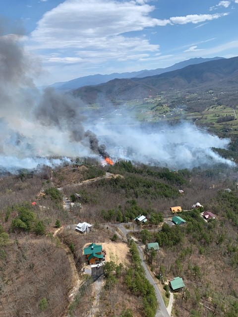
UPDATE MARCH 31: The Hatcher Mountain/Indigo Lane fire continued to burn this afternoon on the ridges west of Wears Valley, where the wildfire has already destroyed numerous rental cabins and homes.

Sevier County Emergency Management Agency officials said they were beginning to assess the loss of structures, and urged people not to call 911 for the status of their properties. 

The fire is believed to have started Wednesday in the Indigo Lane area in Sevier County. Days of low humidity and an overall shortage of rain prompted the National Weather Service to note heightened fire danger earlier this week, and it warned of high winds Wednesday morning. A gust of 60 mph was recorded overnight at Knoxville’s McGhee Tyson Airport. The fire has now consumed at least 2,500 acres since Wednesday.

A state forestry official told WBIR that some rainfall, increasing humidity and decreasing winds have allowed crews to be more aggressive with firebreaks, but the fire is still less than 10 percent contained.

Multiple municipal fire departments, including Knoxville, Oak Ridge, Chattanooga, and smaller agencies, such as Oliver Springs and Cosby, have responded with mutual aid.

Early spring is a natural time for fires in the Southern Appalachians due to fuels accumulated over fall and winter and the potential for dry and windy conditions.

Fall is the other main wildfire timeframe, and that was illustrated in horrible fashion in 2016, when a wildfire that started at the Chimneys in Great Smoky Mountains National Park eventually swept into developed areas around Gatlinburg. That fire killed at least 15 people and destroyed thousands of structures. Notable scars from the fire remain.


WEARS VALLEY Wind-driven wildfires closed in Wednesday evening on dozens of rental cabins and permanent homes perched on Hatcher Mountain above Wears Valley in Sevier County near the border of Great Smoky Mountains National Park.

Authorities ordered mandatory evacuations; media reports indicate several structures have already burned. At least one injury is reported. Wears Valley Road is closed between Pigeon Forge and Townsend.

Sevier County Emergency Management said in a 3:17 p.m. tweet: “A mandatory evacuation is in place for the Hatcher Mountain area of Wears Valley, and the resorts of Shagbark and Little Valley. Residents near these areas should also evacuate.” WBIR reports the fire now covers 250 acres west of Wears Valley Road (U.S. 321) and is not contained at all at this point. Firefighters from multiple agencies were headed to the scene, where backfires were being set.

The wildfire advances as fire crews try to get the upper hand on another forest fire along the southern boundary of Great Smoky Mountains National Park. The Thomas Divide fire, sparked by fallen power lines, encompasses 940 acres and is 60 percent contained, according to the park service. Other forest fires have been reported in recent days in the Knoxville metro area.

The federal government has also assigned 20 firefighters to the Hatcher Mountain/Indigo Lane fire in Wears Valley, according to the park service.

The National Weather Service has warned for several days of high wildfire danger given very low humidities and high winds. A high-wind warning is in place for most of East Tennessee and the mountains.

Rain is expected overnight, but wind gusts could approach 90 mph in the Smokies, according to the weather service.

Rate this item
(1 Vote)

Related items

  • ORNL researcher models fire’s growing footprint in a changing climate
    in News

    COVER 1208 GatlinburgsInferno3Wild turkeys forage in charred hardwood forest soon after the 2016 Gatlinburg fires, which moved from the Smokies to developed areas in Sevier County. An ORNL model predicts wildfire threats will increase in the Southern Appalachians because of climate change. Thomas Fraser/Hellbender Press via Knoxville Mercury

    ORNL report: Local wildfire danger will likely loom larger because of climate change

    OAK RIDGE — This cruel summer, the Southern Appalachian region is already baking in above-normal temperatures and basking in poor air quality. 

    Air temperatures in Knoxville flirted with 100 degrees on July 6, which were well above average and prompted the National Weather Service to issue a heat advisory for much of the metropolitan area.

    It’s hard to definitively link a heat wave to global warming, but one oft-cited consequence of climate change is the growing intensity of wildfires, even in the traditionally moisture-rich Appalachians. The range of climate change effects is difficult to pin down, but one constant in the study of climate change is an expected increase in overall temperatures, which can power wildfires via both fuel increases and volatility.

  • Burned in memory
    in News

    Ogle2

    UT Libraries history project records recollections and remembrances of terrible Smokies wildfires

    The results of an ambitious effort by University of Tennessee Libraries to capture the history and personal memories of the devastating 2016 Great Smoky Mountains wildfires are now accessible online five years after the disaster.

    The Smokies fires of 2016, which came to a horrible head over that Thanksgiving weekend, killed at least 14 people and countless domestic pets and wild animals. Gale-driven flames burned through thousands of acres in the national park before escaping the boundary and destroying thousands of homes and other structures in Pigeon Forge, Gatlinburg and smaller communities throughout Sevier County.

    “The social, cultural, economic, political, and natural impacts of this event are still being calculated,” according to UT Libraries.

    Rising from the Ashes: The Chimney Tops 2 Wildfires Oral History Project, organized with the city of Gatlinburg and the Anna Porter library, collected 140 video and audio interviews with those impacted by the fires, including survivors, government leaders, first responders, scientists, clergy, journalists and mental health experts.

    “This project documents one of the most momentous events in modern Tennessee history — in the voices of those who lived it,” said Steve Smith, dean of the UT Libraries in a news release.

    “The collected stories document more than tragedy, however; they testify to the resilience of the human spirit. Our team is honored to help preserve these stories for history, study, learning, and research.”

    All interviews are preserved within the UT Libraries’ Betsey B. Creekmore Special Collections and University Archives.

    The 2016 Thanksgiving wildfire, which began on the Chimneys deep within the national park, was the largest in the eastern U.S. since the 1940s. It burned 17,000 acres, injured at least 200 people and forced the evacuation of thousands, according to UT Libraries. 

    “Visitors to the Rising from the Ashes website can approach the topic through different lenses such as the evacuation efforts, the disaster response and recovery, or the ecological impact; hear from medical personnel, business owners, or individuals directly affected by the wildfires; or simply browse through the recorded interviews,” according to a release announcing the final posting of the project.

    P1020883

  • Pellissippi Parkway punches: Vocal opposition slams highway extension plans at public meeting
    in News

    1624321366689

    UPDATED: Opponents of Pellissippi Parkway Extension hammer bureaucrats, unelected economic development officials at public meeting

    (This story has been updated with this link to the Tennessee Department of Transportation recording of the Sept. 21 public hearing on the proposed Pellissippi Parkway Extension project).

    Raw emotions spilled over at a Tennessee Department of Transportation public meeting to collect citizen input on a nearly 5-mile, four-lane highway that would carve through creeks, forests, farms and homes in rural Blount County in the foothills of the Great Smoky Mountains.

    The meeting was held Tuesday evening at Heritage High School, not far from where the proposed Pellissippi Parkway Extension (which would originate at the terminus of the current parkway near Rockford) would abruptly bisect East Lamar Alexander Parkway, just to the west of Walland Gap and the Little River Gorge.

    As Hellbender Press has reported on the Pellissippi extension, many people aren’t happy with the proposition of spending at least $100 million on a 4.5-mile stretch of highway, and people are uncomfortable with both the use of eminent domain to force them from their homes or seize portions of their property and the unavoidable and long-lasting environmental and cultural impact such a project would have on the rural areas of Blount County. The projected cost of the project has vacillated by millions of dollars.

    East Lamar Alexander Parkway (U.S. 321) terminates in Townsend; along the way are turnoffs to many valuable pieces of real estate and immensely successful high-end hospitality venues, such as Blackberry Farm. Hellbender Press reached out to Blackberry Farm through its Nashville-based public relations team about the nearby highway project and was simply told “we have no comment.”

    People who did not attend last night’s meeting have the opportunity to voice their opinion on the TDOT website.
     
    The comment period is open through Oct. 12.