Thomas Fraser
ORNL’s comprehensive mapping of built environments aids disaster response
Compass: ORNL mapping effort will aid rescue, risk assessment
Oak Ridge National Laboratory scientists spent five years mapping virtually every structure in the U.S. and the data is bearing early fruit as it is used for response to disasters such as hurricanes and severe floods.
Mark Tuttle and Melanie Lavardiere, the team leaders of the project, have mapped “virtually every single structure in the United States and its territories,” Compass reports.
The information is used by disaster responders from the FEMA level and down. During a hurricane, for example, authorities can focus response efforts on the most vulnerable areas using the building-mapping database.
The database can also be used by insurers to charge rates more according to risk, and for structures covered under the National Flood Insurance Program, as is already happening.
But the data is most valuable for saving lives and determining the most likely location those lives will have to be saved.
“After disaster strikes, the data can give a rapid indication of the scope of the damage and point responders in the right direction to assist in the recovery. Using the powerful computers available at ORNL, the team can process data quickly — producing in a matter of hours work that used to take months — and get it into FEMA’s hands for analysis,” Compass reports.
Feds reopen plans for long-delayed 9-mile Foothills Parkway segment from Wears Valley to Gatlinburg near Great Smoky Mountains National Park

Plans for new parkway segment were hatched long ago; project would also include improvements to Wears Valley park entrance
Just a few years after the “Missing Link” of the Foothills Parkway was finally finished following decades-long delays, the National Park Service now has its sights set on constructing a new 10-mile section of parkway on the Tennessee side of Great Smoky Mountains National Park that would extend from Wears Valley to the heavily traveled Gatlinburg Spur.
The leg of the roadway has long been included in a plan for full completion of the parkway. About 30 miles have been completed from Tallassee, Tennessee to Wears Valley. This section would extend from the current parkway terminus in Wears Valley to the Gatlinburg Spur near Pigeon Forge.
Park officials said in a press release announcing the opening of the project’s public comment period that the unfinished section is the only stretch of incomplete, congressionally approved roadway in the U.S.
Catch a beer and documentary on the importance of freshwater fish and their current swim into oblivion
Albright Grove Brewing Company will host a viewing Wednesday, Sept. 29 of “Hidden Rivers,” a documentary detailing the smaller, gilled denizens of Southern Appalachian creeks, rivers and streams and the threats they face.
The screening of “Hidden Rivers” by Freshwaters Illustrated is planned for 6 p.m. at Albright Grove Brewing, 2924 Sutherland Ave. in Knoxville.
“This film aims to show off the stunning freshwater biodiversity of the Southern Appalachian region, and to highlight conservation efforts, beauty, and vulnerability of these ecosystems,” according to Conservation Fisheries, a Knoxville-based nonprofit geared toward the preservation of native Appalachian fishes and their ecosystems.
Conservation Fisheries is in its 35th year of breeding, sharing and releasing broods of threatened fishes collected from points ranging from the Conasauga River to Little River and beyond.
Another slice of the wild preserved in Cumberlands
Knox News: Nearly 12,000 acres added to Skinner Mountain preserve on the Cumberland Plateau
The Conservation Fund and state wildlife and forestry officials reached a deal to conserve and manage thousands of wild acres in Fentress County.
The expanse was previously held by an out-of-state speculative investment company likely originally tied to timber companies.
The Cumberland Plateau and escarpments have been increasingly recognized for their biodiversity along with the Smokies to the east beyond the Tennessee Valley. The Cumberlands are along a songbird and fowl migration route, and host a niche population of mature timber, mosses, lichens, fungi, mammals and amphibians. Elk were reintroduced a decade ago, and black bears have begun to range across the Cumberlands and their base.
The area is pocked with caves and sinkholes, some containing petroglyphs and other carvings from previous populations.
"On the Cumberland Plateau, the key to maintaining biodiversity is to retain as much natural forest (both managed and unmanaged) as possible," a forestry expert told the News Sentinel's Vincent Gabrielle.
The Foothills Land Conservancy has also helped protect thousands of acres along the plateau and its escarpments in recent years.
Pellissippi Parkway punches: Vocal opposition slams highway extension plans at public meeting
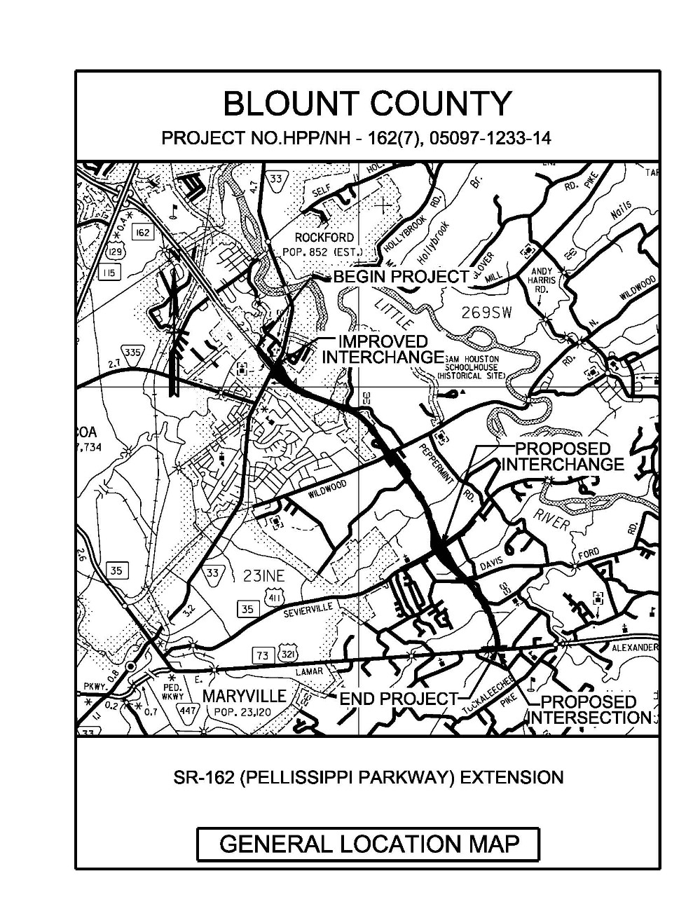
UPDATED: Opponents of Pellissippi Parkway Extension hammer bureaucrats, unelected economic development officials at public meeting
(This story has been updated with this link to the Tennessee Department of Transportation recording of the Sept. 21 public hearing on the proposed Pellissippi Parkway Extension project).
Raw emotions spilled over at a Tennessee Department of Transportation public meeting to collect citizen input on a nearly 5-mile, four-lane highway that would carve through creeks, forests, farms and homes in rural Blount County in the foothills of the Great Smoky Mountains.
The meeting was held Tuesday evening at Heritage High School, not far from where the proposed Pellissippi Parkway Extension (which would originate at the terminus of the current parkway near Rockford) would abruptly bisect East Lamar Alexander Parkway, just to the west of Walland Gap and the Little River Gorge.
As Hellbender Press has reported on the Pellissippi extension, many people aren’t happy with the proposition of spending at least $100 million on a 4.5-mile stretch of highway, and people are uncomfortable with both the use of eminent domain to force them from their homes or seize portions of their property and the unavoidable and long-lasting environmental and cultural impact such a project would have on the rural areas of Blount County. The projected cost of the project has vacillated by millions of dollars.
East Lamar Alexander Parkway (U.S. 321) terminates in Townsend; along the way are turnoffs to many valuable pieces of real estate and immensely successful high-end hospitality venues, such as Blackberry Farm. Hellbender Press reached out to Blackberry Farm through its Nashville-based public relations team about the nearby highway project and was simply told “we have no comment.”
- pellissippi extension right of way
- pellissippi parkway extension
- pellissippi public hearing
- little river
- threats to little river
- little river endangered fish
- rockford
- east lamar alexander parkway
- opposed to pellissippi parkway extension
- citizens against the pellissippi parkway extension
- cappe
- townsend
- rural blount county
- tdot public hearing on pellissippi parkway extension
- walland
- little river gorge
- great smoky mountains national park
- great smoky mountains national park visitation
- us 321 to townsend
- video of pellissippi parkway extension hearing
Share your ride and learn about other electric whips during Drive Electric Week
One of the biggest electric vehicle loads in state history is set for Saturday at Pellissippi State Community College in Knoxville.
The Knoxville Electric Vehicle Association; Pellissippi State Community College; and Drive Electric Tennessee are all plugging to make the 2021 Knoxville Drive Electric Week Event the largest ever in the state, according to organizers.
Vendors, test drives and educational activities will be held on the PSCC Hardin Valley campus just off Pellissippi Parkway from 10 a.m. to 3 p.m. Saturday, Sept. 25.
The only criteria for displaying your electric scooter, ATV, car or motorcycle: They must be plugged in to recharge. Everyone who drives an electric vehicle, or is interested in alternative fuel sources, is welcome to attend.
J.J. takes a bus down Electric Avenue
![884E1F2D 2A2F 4F68 A15E 80F9458D1FB0]() Hard Knox Wire: City takes media and politicos on a spin aboard KAT’s newest electric bus
Hard Knox Wire: City takes media and politicos on a spin aboard KAT’s newest electric bus

The city demonstrated and offered rides aboard the Knoxville Area Transit’s new electric buses at Caswell Park on Thursday. The city and Knoxville Area Transit (KAT) plan to acquire a total of 18 electric buses as part of a plan to reduce the city’s carbon emissions by 80 percent over the next thirty years. Five of the buses, built by Canada-based manufacturer New Flyer, have arrived.
“In the United States, transportation is the largest contributor to greenhouse gas emissions and consequently climate change. Transit has the power to change that,” city transit director Isaac Thorne told Hard Knox Wire.
“By drawing new people to consider transit, reducing reliance on cars, opening up opportunities, and providing sustainable mobility choices, transit can make cities more livable, make the air cleaner, and help meet our challenging but achievable climate goals,” he said.
The city plans to have 18 electric buses representing 26 percent of KAT’s fleet in regular operation by the end of next year. Another 41 percent of the existing fleet are hybrids, according to KAT.
The Knoxville Utilities Board is installing multiple chargers to service the electricity needs of the new fleet.
The new buses will undergo multiple trial runs before they hit the road with public passengers in January, probably along the Sutherland and Magnolia routes.
“KAT’s fleet of 71 buses carry around 3 million passengers each year on its 23 bus routes and three downtown trolley routes. There are 1,150 bus stops scattered throughout the city, and bus routes come within a half-mile of 80 percent of the population,” Hard Knox Wire reported.
“Today marks a dramatic milestone for Knoxville — this is a major step on our path toward a more clean and resilient future for our children and grandchildren,” Mayor Indya Kincannon said in a news release from KAT.
“These high-efficiency electric buses are an investment in clean air, in healthy neighborhoods, and mobility for our residents.”
Deadly natural disasters have ravaged hardscrabble Knoxville for generations. Covid-19 takes the cake.
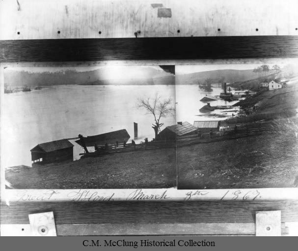
Hard Knox Wire: A brief history of Ktown's worst natural disasters
The Covid-19 pandemic currently could go down in history as Knoxville's worst hard time (to borrow a phrase from Timothy Egan), but a litany of natural disasters preceded the international outbreak of respiratory disease that killed 629 people in Knox County as of Sept. 8, according to the Knox County Health Department. Only half of the county's residents have been vaccinated, according to a New York Times database, and more than 10 percent of the population has been infected with Covid-19, which can carry life-long health implications.
Hard Knox Wire has a great rundown of the Covid crisis and other natural disasters that the city and region have faced in its ongoing Knoxville history series. They include the far-flung effects of the New Madrid earthquake; periodic flooding that devastated downtown and outlying areas before TVA dammed the Tennessee River; a Cocke County plane crash that killed all aboard, including noteworthy Knoxvillians; and, perhaps, appropo, the smallpox and cholera breakouts that struck the city in the 1800s.
History is a great teacher, and thanks to JJ Stambaugh of Hard Knox Wire and Jack Neely of the Knoxville History Project for keeping us on our toes in regard to the past.
Dozens of oil spills tracked in Gulf of Mexico nearly two weeks after Hurricane Ida

Washington Post: Thousands of reports spill in about pollution following Hurricane Ida
It was a perfect storm of imperfect planning that led to southern Louisiana's prominent role as both a producer and transporter of fossil fuels -- and its vulnerability to storms such as Hurricane Ida.
Ida pitched one of the highest hurricane gusts (175 mph) ever recorded in the U.S. when it came ashore at Port Fouchon. Its storm surge also inundated and destroyed both residential neighborhoods and refineries, pumps, pipelines and petroleum storage facilities associated with the high-dollar, polluting petrochemical complex of southern Louisiana.
The Coast Guard is tracking 350 documented oil spills that have occurred since Ida's violent arrival on Aug. 29. Overall, the Washington Post reported "the Coast Guard has received 2,113 reports of pollution or contamination in the waterways to date, with plans to follow up on each.
"The most significant incident so far has been the oil spill off Port Fourchon, in a lease area known as Bay Marchand Block 5," the Post reported.
The Gulf Coast and gulf itself are littered with thousands of miles of abandoned pipelines and imperfectly capped wellheads. Ida ruptured many, but this is a common headline every time a hurricane strikes the Gulf Coast. It just seems to be getting worse.
Park service seeks public input on regulation of Smokies helicopter flights
A public input session has begun as part of a joint effort between the Federal Aviation Administration and the National Park Service to establish limited helicopter tour routes over Great Smoky Mountains National Park along with protocols geared to reduce the environmental and visitor impact of the flights.
The flights are already occurring, and have been for years; park service officials said in a news release that 946 flights per year would be allowed under the Air Tour Management Plan, in line with current levels of helicopter tours conducted each year by two operators outside the park.
The park service and FAA plan a virtual public meeting on the proposed tour routes at 4:30 p.m. Sept. 16. Public comment is accepted through Oct. 3, and can be entered into the record at the Smokies Air Tour Management Plan website.
"Great Smoky Mountains National Park is among 24 parks of the National Park System developing air tour management plans in cooperation with the FAA," park officials said in a press release.
"The agencies hope to complete all air tour management plans by the end of August 2022. The schedule is part of a plan approved by the U.S. Court of Appeals for the District of Columbia Circuit for the agencies to comply with the National Parks Air Tour Management Act of 2000 within two years."