Water (31)
Ancient river, new threats: Water quality officials declare 19 miles of French Broad River in NC impaired by pollutants
Written by Jason Sandford Recreational uses of the French Broad River in Asheville, including tubing, kayaking and canoeing, have grown dramatically in recent years. Jason Sandford/Ashevegas Hot Sheet
Booming construction and development, combined with more frequent heavy rains and an aging stormwater system, continue to threaten the age-old Appalachian river
This story was originally published by Jason Sandford of the Ashevegas Hot Sheet.
ASHEVILLE — North Carolina water quality officials declared a 19-mile section of the French Broad River in Buncombe County as officially “impaired” because of fecal coliform levels found during recent testing. It’s a sobering alarm bell (though there have been plenty of warning signs, as you’ll see below.) In Asheville, interest in the river as an economic force and tourist destination has never been higher. (The confluence of the French Broad and Holston rivers forms the Tennessee River above Knoxville.)
The designation will come as no surprise to even casual observers of the wide, northward-flowing river. Often, it runs a chocolate brown color, a clear sign of the sediment and other pollutants running through the waterway.
- french broad river
- ashevegas
- jason sandford
- asheville environment
- is french broad river clean
- tubing in asheville
- fecal coliform french broad
- is french broad part of tennessee river
- what direction does the french broad flow
- kayaking on french broad
- hot springs environment
- french broad sedimentation
- french broad impaired river
- is french broad river polluted?
- what forms the tennessee river
- french broad river asheville
- river health
- threats to french broad river
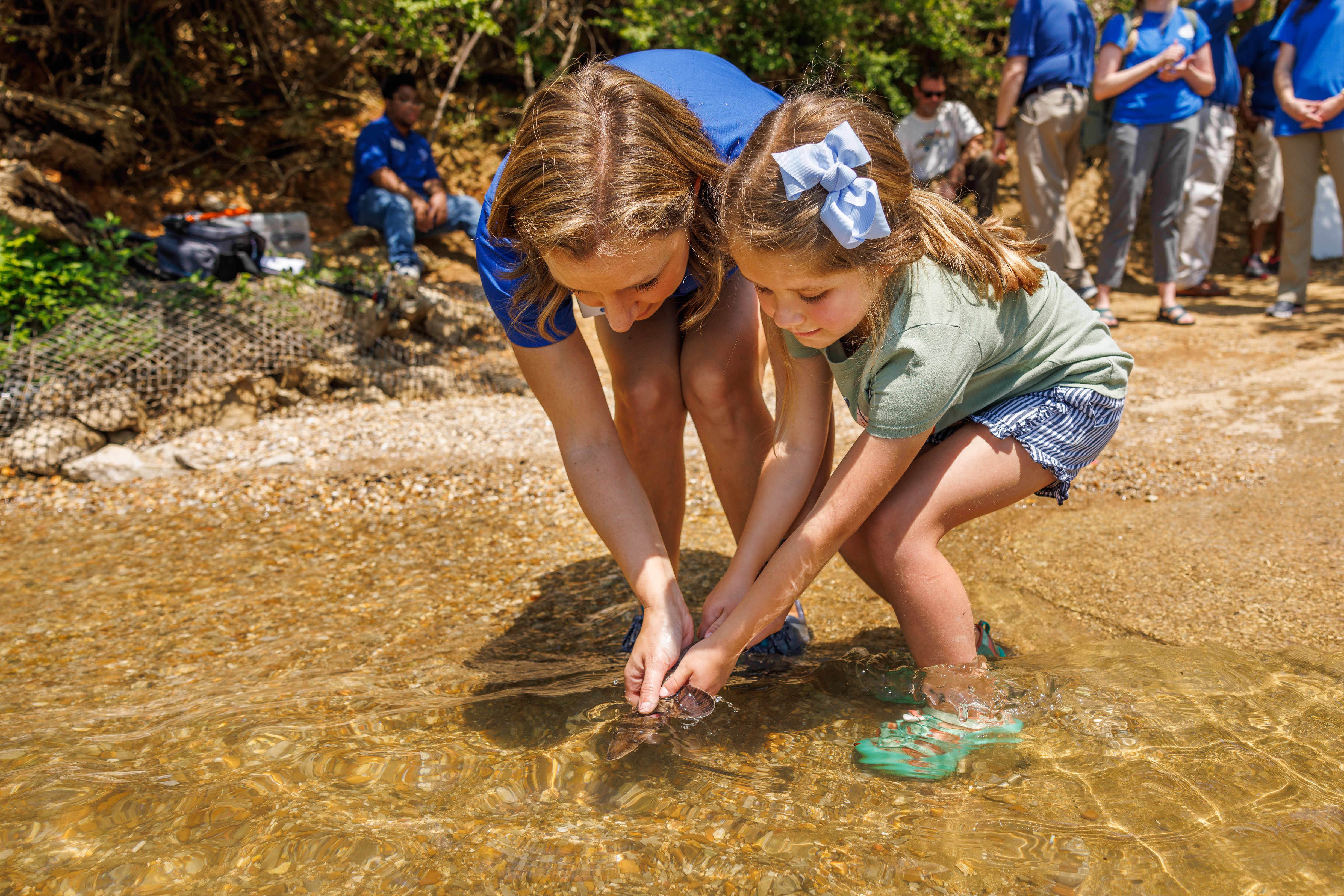 Tennessee Aquarium Director of Hospitality and Marketing Meredith Roberts and her daughter Lucy release a juvenile lake sturgeon during an Earth Day event on the Chattanooga riverfront. Tennessee Aquarium
Tennessee Aquarium releases endangered sturgeon on a fin and a prayer
CHATTANOOGA — Lake sturgeon are living fossils.
They are dinosaur fish. They have no scales. They are protected by a tough skin with boney plates, and are unchanged for millennia. They are part of a widespread related group of fish, with 23 species worldwide, and are an endangered species in Tennessee.
Tennessee Aquarium staff released some of these dinosaurs into the Tennessee River here on Earth Day, observed this year on April 22. Aquarium staff were joined by 30 students from Calvin Donaldson Elementary School and the public to release 65 juvenile lake sturgeon into the Tennessee River at Chattanooga’s Coolidge Park.
Maybe we should call it Ocean Day
Written by Wolf NaegeliBest Earth Day feature: We still know so little about so much that is vital to life on our planet
CBS News — Stunning midwater creatures of the deep sea
You have to endure a half-minute commercial to see this 6-minute report on the fascinating footage captured by a high-tech marine science project of the Monterey Bay Aquarium.
Make sure to turn on full-screen viewing, if you can. Have you ever seen a bloody belly comb jelly?
We think you’ll agree it’s the most worthwile video you watched today.
Tennessee Aquarium floats citizen-scientist app to extend the reach of public research
Written by Ray Zimmerman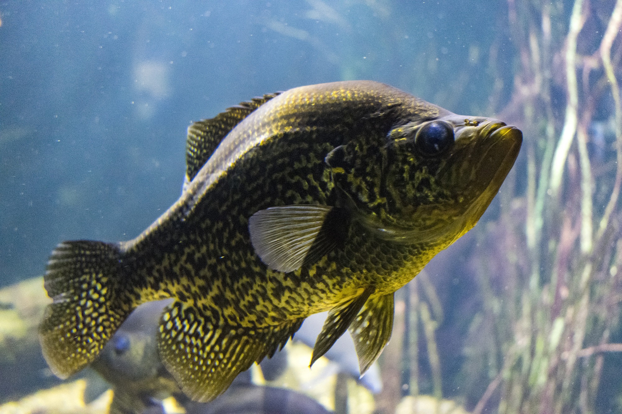 A black crappie is seen in the Tennessee Aquarium. Citizen scientists across the region can now plug their fish findings into a new database. Courtesy Tennessee Aquarium
So you want to be a citizen scientist? There’s a new app for that!
The Tennessee Aquarium Conservation Institute wants to assess the status of various fish populations throughout the Southeast so it released a new app to help outdoor folks and anglers identify the fish they spot, report the sighting, and enter their discoveries into a regional fish database.
The Freshwater Information Network (FIN) accepts and includes data for three major watersheds: The Tennessee and Cumberland rivers, and Mobile Bay.
Tennesseans may be familiar with the two rivers, but may think of Mobile Bay as a distant place with no connection to them, but its headwaters touch Tennessee in the Conasauga River. With its geographic isolation, the Conasauga is home to species of fish found nowhere else in the world.
Our region has more species of fish than any other part of the country, and the open FIN database and application includes information on nearly half the U.S. species of fish. When hikers, boaters or anglers spot a fish, they can participate by first photographing it and then uploading the photograph to the app.
 A wharf seen along the Tennessee River in Knoxville in the late 1800s or later. Knoxville History Project via Hard Knox Wire
Q&A with Knoxville historian illustrates the importance of the Tennessee River to nascent Knoxville
Rivers didn't need early American cities, but the cities certainly needed rivers.
Knoxville historian Jack Neely and Hard Knox Wire editor J.J. Stambaugh lay out a fascinating history of the Tennessee River through Knoxville in their latest collaboration. And yes. It has several references to “Suttree” by Cormac McCarthy. Of course.
“Beyond in the dark the river flows in a sluggard ooze toward southern seas…. afreight with the past, dreams dispersed in the water someway, nothing ever lost.” — Cormac McCarthy, “Suttree”.
The Tennessee River doesn’t loom large in the daily lives of most contemporary Knoxville residents, but two centuries ago it was literally why there was a city here in the first place.
In fact, it’s impossible to discuss Knoxville’s history for long without the river cropping up in one way or another. In the earliest days of the community’s existence, settlers drew water from and washed in the creeks that fed the Tennessee; the river itself carried boats laden with goods hundreds of miles before ending up in New Orleans and the Gulf of Mexico.
Since then, the city’s relationship with the river has evolved steadily. It was an economic lifeline for generations, but railroads and automobiles eventually cornered the market when it came to shipping both cargo and passengers. Today, it’s a safe bet that when most people think of the “Riverfront” they’re thinking of restaurants or maybe a fireworks display; for the lucky few who can afford to belong to the yacht club, they’re maybe thinking about Labor Day weekends spent sailing with the Vol Navy.
In the latest edition of Hard Knox Histories, local historian and journalist Jack Neely discusses the ebbs and flows of Knoxville’s connection to the river with HKW’s editor, J.J. Stambaugh.
J.J.: When the first settlers arrived at the site that would be Knoxville, what role did geography — especially the Tennessee River — play in their decision to settle here? How important was the river commercially in the early days? The river, of course, was fed by numerous tributaries and creeks. How important were relatively small waterways like First Creek to the early city’s growth?
JACK: The river was elemental. It was hard to start a city without one. It was transportation, it was water for drinking and cooling, it was waste disposal. And, of course, the Tennessee reached from here into Cherokee territory, beyond into Alabama, then through West Tennessee into Kentucky, and all the way to the Ohio and the Mississippi.
When it came to locating a city, First Creek was probably as important as the Tennessee because it provided mill power. There were several mills up and down First Creek, as well as Second Creek. The two downtown creeks were the eastern and western boundaries of the city for its first 70 years or so.
The river was extremely important commercially, even though it was a mostly one-way thing. In the early days, when Knoxville was a territorial and state capital, there was a demand for liquor here, and folks apparently got so good at producing cheap whisky and brandy that they loaded flatboats with it and floated them downriver, all the way to New Orleans, where it could be sold for several times the cost. I love the fact that riverboat crewmen would bust up their rafts and sell them for hardwood in a city where there wasn’t much of it. A lot of the wooden buildings in the French Quarter, especially in the interiors, show traces of the rope holes and grooves characteristic of flatboats.
Go to Hard Knox Wire for the rest of this fascinating story.
Memphis City Council bans Byhalia Pipeline over aquifer contamination concerns
Written by Thomas Fraser Memphis residents have pushed back against the Byhalia Pipeline project. The proposed pipeline has been the subject of controversy since 2019. The joint venture project would build a 49-mile pipeline between Memphis and Mississippi and would run through several Black communities in Memphis. VALERO Memphis Refinery, shown here, is along the Mississippi River’s Lake McKellar in South Memphis. Photo by Karen Pulfer Focht
Opponents of Memphis pipeline cite textbook examples of environmental racism
(This story was originally published by Tennessee Lookout).
Memphis City Council passed an ordinance this month protecting the Memphis Sand Aquifer after environmental activists spent nearly a year fighting to protect it against a crude-oil pipeline.
The city council passed on second reading an ordinance establishing the city government’s role in overseeing future developments in Memphis and how they may impact the aquifer, which serves as the area’s main drinking water supply.
The ordinance will be up for a third and final vote on Aug. 17.
Since 2019, environmental and racial justice advocates have protested plans to build the Byhalia Pipeline, a joint venture between Texas-based Plains All American Pipeline and Valero Energy Corporation, in a historically Black neighborhood located in Southwest Memphis. What started as criticisms turned into full-blown protests that gathered national attention and support from prominent political figures, including former Vice President Al Gore and civil rights leader the Rev. William Barber.
The council used the Federal and Tennessee Safe Drinking Water Act as an authorizing agent for local government’s ability to protect public drinking water.
The Memphis City Council first discussed legislation to protect the aquifer in May 2021 and introduced ordinances that would affect the Byhalia Pipeline.
The resolution established an Underground Infrastructure Advisory Board to review all future developments within Memphis and prohibit those that carried hazardous liquids. According to council documents, developments must not pass within 1,000 feet of the Wellhead Protection Areas, which access existing public water supplies.
Byhalia Pipeline representatives threatened to file a lawsuit against the city council if they were to pass legislation that regulated future developments, causing the council to delay the vote.
Byhalia Pipeline representatives then abandoned the project in July but said they still considered filing a lawsuit if the resolution were to pass.
Councilman Jeff Warren, who sponsored the resolution, said “lawsuits are always possible.”
Local community leaders and critics called the Byhalia Pipeline an example of environmental racism, adding that Memphis communities were already burdened by harmful environmental issues caused by nearby oil refineries, wastewater treatment facilities, industrial manufacturers and power plants.
These factors led to cancer risks four-times the national average, and any contamination of the area’s drinking water could potentially turn the area into another Flint, Michigan, a city whose water system was contaminated with lead.
Biodiversity in crosshairs as burgeoning Middle Tennessee fears water shortage
Written by Anita Wadhwani This biologically rich stretch of the Duck River could soon be the site of a large municipal water intake facility.
Duck River targeted by thirsty, growing municipalities in Nashville area
This story was originally published by Tennessee Lookout
Marshall County, located outside what was once considered the boundary edge of growing suburbs circling Nashville, has seen explosive growth of its own in recent years — call it the Williamson County overflow effect, says County Mayor Mike Keny.
Drawn by more affordable housing, jobs and the rural character of the county — about an hour from Nashville in the “heart of the Southern Automotive Corridor” (as local economic development officials call it) — the influx of residents, and some relocating business and industry, has brought new urgency to a long-standing reality.
The county doesn’t have its own water supply. For decades, it has had to pay wholesale for drinking water from the cities of Murfreesboro and Lewisburg. That supply is no longer adequate.
A new proposal by county officials calls for building a water treatment facility along the banks of the Duck River in northern Marshall County capable of siphoning up to 6 million gallons of water per day; establish a reliable local water supply for decades to come.
- tennessee water supply
- murfreesboro water
- tennessee lookout
- williamson county water supply
- duck river
- biodiversity
- mussels
- most biologically diverse river in the united states
- duck river biodiversity
- most biodiverse us river
- drinking water
- water treatment facility
- water supply
- urbanization
- marshall county tn
- southern automotive corridor
- tennesse wildlife resources agency
- aquatic biodiversity
- pale liliput mussel
- rabbitsfoot mussel
- the nature conservancy
- tennessee department of environment and conservation
- tdec
- twra
As our streams and rivers suffocate, Tennessee regulators plan to loosen runoff rules at construction sites
Written by Anita Wadhwani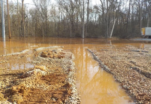 Grading work at a site off Maryville Pike in Knoxville led to silt discharges that resulted in several notices of violation from Tennessee and Knox County regulators. Photo courtesy TDEC.
Critics say new rules could run afoul of Clean Water Act
This story was originally published by Tennessee Lookout.
A state plan to rollback longstanding regulations for construction site runoff is drawing opposition from environmental groups who fear that Tennessee creeks and streams will suffer.
Stormwater discharges from construction sites — rainwater that sweeps soil or other particles off-site — can flow into nearby waterways, often creating silt deposits that impact aquatic life and water quality.
Historically, silt has been one of the primary pollutants in Tennessee’s waterways, a paper explaining the proposed new rules from the Tennessee Department of Environment and Conservation, or TDEC, said. Just one millimeter of soil spread over a one-acre site can weigh 5 tons, and “even a minor uncontrolled construction activity can cause major impairment in surface water,” through runoff, the paper said.
Nevertheless, TDEC is proposing significant changes in state environmental oversight of builders, developers, property owners, contractors and subcontractors in controlling runoff.
Despite Covid slowdowns and shutdowns, Smokies draws $1B in 2020 revenue to neighboring communities
Written by Thomas Fraser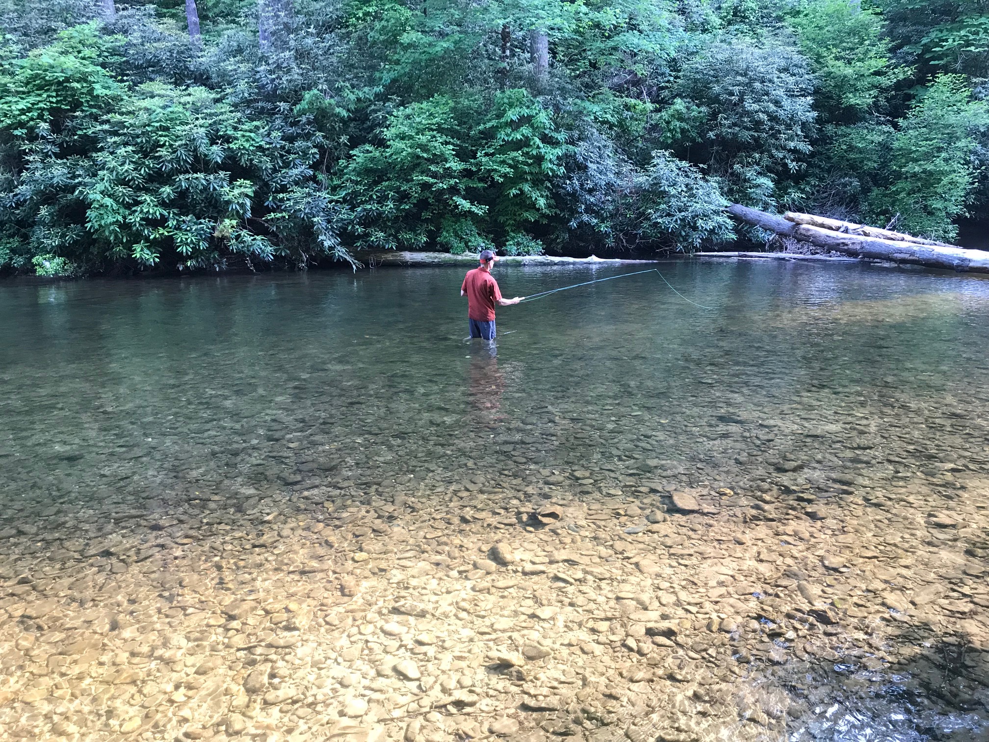 A Knoxville man tries his hand at fly fishing in Abrams Creek during a family camping trip on the southwestern side of Great Smoky Mountains National Park. Thomas Fraser/Hellbender Press
Green begets green in Smokies region; Big South Fork and Cumberland Gap also economic players
Recent federal analysis of spending by national park visitors is a testament to the economic benefits of environmental protection, scientific study and outdoor recreation.
The 12.1 million visitors to Great Smoky Mountains National Park in 2020 spent $1.024 billion in neighboring communities in both Tennessee and North Carolina, according to a study released this week by the National Park Service. Similar, localized releases were distributed into national park communities across the country.
Closer to home, that number represents the estimated visitor money spent in areas that include traditional “gateway” communities, such as Townsend and Gatlinburg, and Cherokee and Bryson City in North Carolina. Regionally, it’s at least a $5 million increase since 2012. Travel problems, housing and employee shortages, overdevelopment and environmental destruction are of course persistent in some of those areas.
- great smoky mountains economic impact
- great smoky mountains national park visitation
- conservation area economic impact
- big south fork
- big south fork national river and recreation area
- economic benefit of wild area
- obed
- cumberland gap
- federal park visitation and spending
- national park service units in tennessee
- economic impact of national parks in tennessee
More...
Tennessee Aquarium and partners are stocking another East Tennessee mountain stream with imperiled Southern Appalachian brook trout
Written by Casey Phillips Juvenile brook trout swim into the water of their new home during a joint effort to return the species to its rightful range in the Tellico River watershed in the southeastern Cherokee National Forest. Photo courtesy Tennessee Aquarium.
In a virtuous cycle of life, native brookies return to Tellico River watershed in southeastern Cherokee National Forest.
(The writer produced this original piece for the Tennessee Aquarium).
Navigating through a thicket of branches while clambering across slick boulders in a rushing mountain stream is a difficult task in the best of times. Doing so while attempting to balance 40-pound buckets of water filled with imperiled fish takes the challenge to an entirely new level.
A team of scientists from the Tennessee Aquarium Conservation Institute drove to one of the lush, high-elevation streams in the southern reaches of the Cherokee National Forest. During a brief lull between rainstorms, they were joined by Tennessee Wildlife Resources Agency representatives and the U.S. Forest Service to celebrate a homecoming for 250 long-lost residents of this gorgeous landscape: juvenile Southern Appalachian brook trout.
Carefully navigating through a snarl of streamside vegetation, participants paused to release five or six trout at a time into pools with overhangs where the young fish could hide from predators and ambush floating insects that washed into the stream. The going was tough, but those involved in the effort to restock almost a kilometer of this pristine creek say the challenge was worth the reward of seeing Tennessee’s only native trout back in its ancestral waters.
“The days when we release fish, especially brook trout, are really special moments,” said Tennessee Aquarium Aquatic Conservation Biologist Dr. Bernie Kuhajda. “We’re with these fish all the way from when we first bring adults into the Conservation Institute to spawn, to watching the eggs start to develop, to the juveniles that are just a few inches long and ready to release here.
“It really is knowing that we get to help restore trout to the full circle of life. Days like today are the culmination of all that work to put trout back into the Southeastern streams where they belong.”
Like many Appalachian streams, this tributary of the North River in the Tellico River watershed hasn’t hosted the brook trout for almost a century. Clearcutting of forests in the early 1900s made waters in the region too warm. Combined with the introduction of brown and rainbow trout, “brookies” were effectively lost from more than 75 percent of the waterways where they once thrived.
- tennessee aquarium
- tellico river
- cherokee national forest
- native brook trout
- brook trout
- tennessee aquarium conservation institute
- heigh elevation stream
- headwater
- tennesse wildlife resources agency
- spawn
- brookie
- southern appalachia
- trout unlimited
- aquatic wildlife
- natural heritage
- research project
- freshwater science
- conservation
- biological diversity
- biodiversity
- watershed

Dollywood joins Tennessee Aquarium effort to limit the introduction of cigarette butts to our shared waterways.
“As all humans need access to clean water, it’s an incredibly important treasure to protect.” — Dr. Anna George, Tennessee Aquarium vice president of conservation science and education.
Cigarette butts are everywhere, and are perhaps so familiar they go unnoticed by the millions of people who pass them on our streets and roads.
Not only are they unsightly, they contaminate our water resources — the puddles after a sudden rainstorm, the streams that flow through our landscapes, and the stormwater drains that ultimately lead to the Tennessee River. The butts quickly break down, polluting water with “tiny plastic fibers and a devil’s cocktail of chemical compounds,” according to the Tennessee Aquarium.
The Chattanooga aquarium has partnered with Keep the Tennessee River Beautiful, an affiliate of Keep America Beautiful, to stem the rising tide of cigarette butts in our waterways.
Dollywood has also embraced the effort, making it the first theme park in the world to recycle all properly disposed cigarette butts.
“One cigarette filter can contain enough toxins to kill aquatic life within two gallons of surrounding water,” said Kathleen Gibi, executive director of Keep the Tennessee River Beautiful.
The action fits the mission of Keep the Tennessee River Beautiful, which is to inspire the public to take action to protect and preserve the Tennessee River and its tributaries across a seven-state region encompassing Virginia, Tennessee, North Carolina, Georgia, Alabama, Mississippi and Kentucky.
Keep the Tennessee River Beautiful and the Tennessee Aquarium have partnered to install cigarette-butt recycling receptacles on the aquarium’s campus. They placed eight of these bins in heavily traveled locations.
“Everybody contributes to the river, whether positively or negatively, so finding stakeholders and inspiring them to take action is what will make the biggest impact,” Gibi said. She also emphasized the importance of the Tennessee Aquarium’s educational programs in protecting water quality.
The aquarium’s eight cigarette-butt bins are among more than 480 such bins that Keep the Tennessee River Beautiful has installed within the river’s watershed. The shared effort will install another 90 during the coming months.
Dollywood is among the 73 sites that have installed bins, making it the first theme park in the world that recycles all the cigarette butts it collects, Gibi says.
Partnering to remove cigarette filters from the river is only part of the aquarium’s ongoing mission to understand the impact on freshwater habitats from microplastics pollution.
Dr. Anna George, the Aquarium’s vice president of conservation science and education, said, “It’s urgent to understand better ways to manufacture and dispose of plastics, so we reduce their impact on the environment.”
The Tennessee Aquarium recently installed a new exhibit in the River Journey Building where visitors can discover the impact of microplastics on freshwater environments. The Tennessee Department of Transportation funded this exhibit as part of their Nobody Trashes Tennessee litter reduction campaign.
In September 2020, the Tennessee Aquarium Conservation Institute and the University of Georgia River Basin Center convened a digital gathering of 50 researchers conducting pioneering studies into the impact of microplastics on freshwater systems.
All forward: Tennessee RiverLine paddle trail offers world-class recreation and reconnects the valley with its river heritage
Written by Thomas Fraser
RiverLine dedicates itself to recreation and retrospect on the storied Tennessee River
In many respects, the United States and Native American nations before it were carved out by paddle blades.
Rivers provided transportation, communications, sustenance and avenues for exploration. They were the genesis of cities large and small.
Americans grew apart from the rivers that watered and nurtured a modern nation, their connections cut by outward growth and industrial development along riverbanks.
Only recently have the great continental rivers again become the centerpieces of redevelopment and modern recreation. One such effort officially launched in Knoxville on May 21 aims to further connect communities in four states with their river again.
A bale of turtles watched from logs embedded in the sediment of the Tennessee River (or more precisely, Fort Loudoun Lake) at Suttree Landing Park near downtown as officials from Knoxville to Paducah, Kentucky celebrated the creation of the Tennessee RiverLine, which will establish continuous paddling, hiking and biking trails along the 652-mile length of the reservoir-regulated river.
The initial effort, which will include enhanced launch and takeout sites, signage and navigational aids, 60 publicly available kayaks, campground enhancement, and publicity, is largely funded by a $400,000 investment shared between the University of Tennessee and Tennessee Valley Authority. The National Park Service is also a partner in the project.
Seventeen private and public groups of the RiverLine Partnership are committed to furthering the development of the trail, including the Nature Conservancy. Other supporters include Muscle Shoals National Heritage Area and the Tennessee Aquarium in Chattanooga.
“These partners have brought so much to the city of Knoxville,” said Mayor Indya Kincannon specifically of UT and TVA during her public remarks at the well-choreographed event in the well-groomed park with the downtown skyline visible under a clear, blue sky to the northwest.
“The Tennessee RiverLine is a continuation of our vision for what makes a healthy city: (which includes) parks and recreation,” she said, also touting the economic, therapeutic and spiritual benefits of ready access to outdoor recreation.
“During this past year, we’ve had a really hard time, dealing with the pandemic, and one thing that has helped me, and so many members of this community, is being able to be outside: being on the river, being in our parks,” Kincannon said.
“That has helped us get through some challenging times, and that’s going to help us into the future.”
The battle of Flenniken Branch
Written by Tracy Haun OwensThis photo was included in a TDEC report compiled March 11. It shows an excavated stream channel amid extensive grading work at 2306 Maryville Pike.
Developer of Maryville Pike property in South Knox County faces multiple state, county citations over alleged sediment pollution
The rapid growth of South Knox County has expanded far from the perimeters of the center city and extended into more development-rich areas.
One case in point: Significant development is taking place along a once-sleepy section of Maryville Pike between Vestal and Rockford.
There is a new entrance to the expanded I.C. King Park and its dog park and playground. Just south, one of the country’s largest home builders is finishing its Sevier Meadows subdivision.
There is another development that illustrates the growing pains and legacy costs that have prompted the county and Tennessee Department of Environment and Conservation to issue a stop-work order and levy multiple fines and citations against the current developer of the old Mayo seed warehouse site.
There are lessons to be learned from a small waterway called Flenniken Branch about the potential impacts of development on aquatic habitats and other public resources — and the ability of the government to protect those resources.
A troubled legacy
Decades of heavy industrial activity left a troubled environmental legacy near the Mount Olive community. Now a new 30-acre construction site is alleged by the state and county to be a significant source of sediment and debris that ultimately end up in the Tennessee River and its tributaries. The state also alleges the contractor buried a stream, and destroyed wetlands at another nearby property.
The Knoxville-based contractor, Kenn Davin, said he is working to correct the violations, but contends the alleged erosion violations are largely the result of runoff from nearby properties, and that the removal of trees from utility rights of way worsened the problem.
To make matters worse, one of those nearby sources of runoff, Davin said, is the so-called Witherspoon property, which was so contaminated by industrial waste the Environmental Protection Agency capped and sealed the site a decade ago.
The property in question is a 28.5-acre parcel at 2306 Maryville Pike, which abuts the Mount Olive Cemetery near Berry Road and was once the site of the D.R. Mayo Seed Co. warehouse.
Mayo sold the property in August 2019 to Florida-based CW Trust. Davin, principal at Knoxville-based contractor Design One, was designated as the site developer.
Over the course of the last 13 months, TDEC’s Department of Water Resources has issued three notices of violation for land disturbances and other impermissible activity at the Maryville Pike property.
The last notice was issued Nov. 20, 2020. Subsequent inspections in January and March noted that Davin was still out of compliance with action steps that had been required by the state.
Davin has not secured the permits required for the significant grading operations on the property, according to the county.
“They have not secured their necessary permits through our department for land disturbance,” said Knox County Stormwater Program Manager Natalie Landry.
Knox County Stormwater Management served a notice of violation for the 2306 Maryville Pike property on Feb. 9, 2021. The developer did not appeal, and a $500 civil penalty was levied.